


[Anchor]
The characteristic of this rain is that it has poured a lot of rain over a narrow area from the central to the southern regions.
Kim Min-kyung, a meteorological expert, will report on the record heavy rain situation over the past two days and the outlook ahead.
[Report]
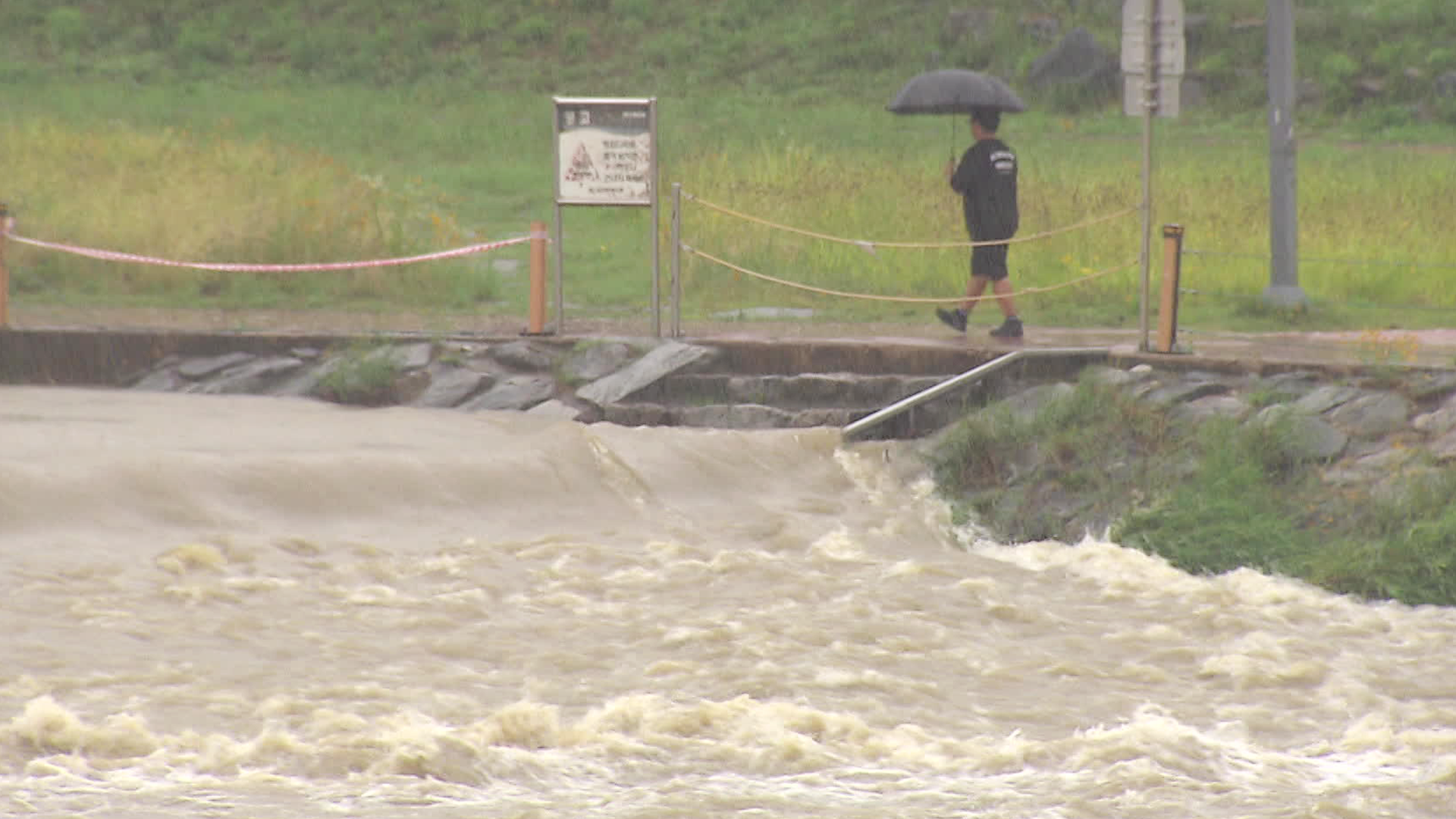
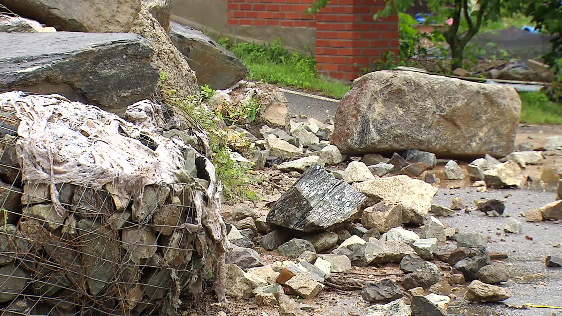
Intense downpours have fallen at every point where the stagnant front has remained, and a flood warning has been issued for the Yudeungcheon River in Geumsan, Chungnam, as the water levels in the Geumgang River basin have risen.
The amount of precipitation is also record-breaking.
As the stagnant front became more pronounced and moved south from the central to the southern regions, heavy rain of up to 50mm per hour fell in various parts of Chungcheong and the south.
Due to the rain that started yesterday (6.20), areas in Chungnam, Jeonbuk, and northern Gyeonggi Province received more than 150mm of monsoon rain, including 193mm in Cheongyang, Chungnam.
In the afternoon, the stagnant front is slowly moving south while remaining over the southern regions.
As a result, rain will also be concentrated in the southern regions overnight, with up to 100mm expected in Jeonnam and Yeongnam, and about 80mm in Jeonbuk and Jeju.
In particular, until dawn tomorrow (6.22), strong rain clouds are expected to pass, bringing heavy rain of 30 to 50mm per hour in various parts of the south.
After that, from tomorrow morning, the stagnant front will move further down to the southern sea near Jeju.
The monsoon rain in the southern regions will gradually stop from tomorrow morning, and in Jeju, it will stop from the afternoon.
[Gong Sang-min/Meteorological Administration Forecast Analyst: "The stagnant front is gradually moving south, so it is expected to mainly affect Jeju Island and some southern coastal areas until early next week, and then it is expected to move north again in the latter half of next week."]
Accordingly, for the time being, monsoon rain will ease in the inland areas, and hot and humid weather is expected to continue.
The Meteorological Administration predicts that the stagnant front will move back north to the central region around next Friday (6.27).
This is KBS News, Kim Min-kyung.
The characteristic of this rain is that it has poured a lot of rain over a narrow area from the central to the southern regions.
Kim Min-kyung, a meteorological expert, will report on the record heavy rain situation over the past two days and the outlook ahead.
[Report]
Intense downpours have fallen at every point where the stagnant front has remained, and a flood warning has been issued for the Yudeungcheon River in Geumsan, Chungnam, as the water levels in the Geumgang River basin have risen.
The amount of precipitation is also record-breaking.
As the stagnant front became more pronounced and moved south from the central to the southern regions, heavy rain of up to 50mm per hour fell in various parts of Chungcheong and the south.
Due to the rain that started yesterday (6.20), areas in Chungnam, Jeonbuk, and northern Gyeonggi Province received more than 150mm of monsoon rain, including 193mm in Cheongyang, Chungnam.
In the afternoon, the stagnant front is slowly moving south while remaining over the southern regions.
As a result, rain will also be concentrated in the southern regions overnight, with up to 100mm expected in Jeonnam and Yeongnam, and about 80mm in Jeonbuk and Jeju.
In particular, until dawn tomorrow (6.22), strong rain clouds are expected to pass, bringing heavy rain of 30 to 50mm per hour in various parts of the south.
After that, from tomorrow morning, the stagnant front will move further down to the southern sea near Jeju.
The monsoon rain in the southern regions will gradually stop from tomorrow morning, and in Jeju, it will stop from the afternoon.
[Gong Sang-min/Meteorological Administration Forecast Analyst: "The stagnant front is gradually moving south, so it is expected to mainly affect Jeju Island and some southern coastal areas until early next week, and then it is expected to move north again in the latter half of next week."]
Accordingly, for the time being, monsoon rain will ease in the inland areas, and hot and humid weather is expected to continue.
The Meteorological Administration predicts that the stagnant front will move back north to the central region around next Friday (6.27).
This is KBS News, Kim Min-kyung.
■ 제보하기
▷ 카카오톡 : 'KBS제보' 검색, 채널 추가
▷ 전화 : 02-781-1234, 4444
▷ 이메일 : kbs1234@kbs.co.kr
▷ 유튜브, 네이버, 카카오에서도 KBS뉴스를 구독해주세요!
- Stalled front brings rain
-
- 입력 2025-06-21 23:21:18
[Anchor]
The characteristic of this rain is that it has poured a lot of rain over a narrow area from the central to the southern regions.
Kim Min-kyung, a meteorological expert, will report on the record heavy rain situation over the past two days and the outlook ahead.
[Report]
Intense downpours have fallen at every point where the stagnant front has remained, and a flood warning has been issued for the Yudeungcheon River in Geumsan, Chungnam, as the water levels in the Geumgang River basin have risen.
The amount of precipitation is also record-breaking.
As the stagnant front became more pronounced and moved south from the central to the southern regions, heavy rain of up to 50mm per hour fell in various parts of Chungcheong and the south.
Due to the rain that started yesterday (6.20), areas in Chungnam, Jeonbuk, and northern Gyeonggi Province received more than 150mm of monsoon rain, including 193mm in Cheongyang, Chungnam.
In the afternoon, the stagnant front is slowly moving south while remaining over the southern regions.
As a result, rain will also be concentrated in the southern regions overnight, with up to 100mm expected in Jeonnam and Yeongnam, and about 80mm in Jeonbuk and Jeju.
In particular, until dawn tomorrow (6.22), strong rain clouds are expected to pass, bringing heavy rain of 30 to 50mm per hour in various parts of the south.
After that, from tomorrow morning, the stagnant front will move further down to the southern sea near Jeju.
The monsoon rain in the southern regions will gradually stop from tomorrow morning, and in Jeju, it will stop from the afternoon.
[Gong Sang-min/Meteorological Administration Forecast Analyst: "The stagnant front is gradually moving south, so it is expected to mainly affect Jeju Island and some southern coastal areas until early next week, and then it is expected to move north again in the latter half of next week."]
Accordingly, for the time being, monsoon rain will ease in the inland areas, and hot and humid weather is expected to continue.
The Meteorological Administration predicts that the stagnant front will move back north to the central region around next Friday (6.27).
This is KBS News, Kim Min-kyung.
-
-

김민경 기자 minkyung@kbs.co.kr
김민경 기자의 기사 모음
-
이 기사가 좋으셨다면
-
좋아요
0
-
응원해요
0
-
후속 원해요
0
오늘의 핫 클릭
실시간 뜨거운 관심을 받고 있는 뉴스
헤드라인


이 기사에 대한 의견을 남겨주세요.